Sixth Major GTN Update Also Incorporates Customized Holds, Fuel Range Rings, and more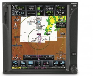

Garmin announced an expanded feature set and new enhancements for the GTN touchscreen avionics. These new capabilities include customer-requested features such as creating and executing customized holding patterns, search and rescue patterns, as well as animated NEXRAD weather imagery from a variety of weather sources. The GTN 650/750 incorporate enhanced navigation functions that are commonly found within popular Garmin Integrated Flight Decks, including the display of fuel range rings, the ability to fly Instrument Approach Procedures (IAPs) with radius-to-fix (RF) leg types and the option to load a secondary approach while flying a missed approach segment. Many of these new features are enabled by a free software update to bring advanced capabilities and even more functionality to the existing GTN 650/750 touchscreen avionics.
Customized Holds
Pilots who fly with the GTN touchscreen series now have the flexibility to quickly build customized holding patterns. These holds may be created over an existing fix in the navigation database or over a user-defined waypoint and inserted into a flight plan or via direct-to navigation. When creating a hold, pilots can easily input inbound or outbound course guidance, select left or right turns and specify leg length in time or distance. Additionally, pilots may input an Expect Further Clearance (EFC) time, which populates a message on the display of the GTN as a reminder to depart the hold or contact ATC. Unpublished holds or those assigned by air traffic control are easily created and displayed on the GTN 650/750 to simplify the process of flying a holding pattern. With a compatible autopilot, this process is further simplified to support flying the entry of the hold and the holding pattern.
NextGen Navigation Capability
Gar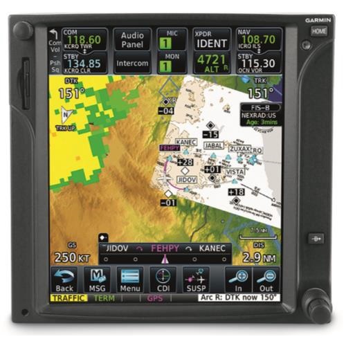 min has expanded the GTN’s navigation capability to include radius-to-fix (RF) leg support, providing customers with the GTN 650/750 additional instrument approach options. With the GTN touchscreen series and a digital Horizontal Situation Indicator (HSI), including the G500 or G600 flight displays, pilots can now fly RF leg types, which are sometimes found in complex Instrument Approach Procedures. This new capability provides pilots and operators with greater access to airports in areas of the world where instrument approaches are nestled among terrain-challenged environments. Additional instrument approach enhancements include the option to load a secondary approach during the missed approach segment, so pilots can have additional time to prepare for the next approach sequence. For added situational awareness, waypoints prior to the final approach fix (FAF) are also displayed when selecting a vectors-to-final (VTF) transition. Additionally, smoother flight plan mapping takes aircraft speed into consideration, resulting in newly designed curved flight plan segments, as opposed to rigid, point-to-point flight plan connections. These new curved segments allow pilots to better anticipate turns based on airspeed.
Animated NEXRAD Radar
Weather-related decision-making is easier with the GTN 650/750, which helps pilots interpret datalink radar imagery more easily by animating a variety of radar sources. The GTN animates precipitation from several weather sources, including Flight Information Service-Broadcast (FIS-B) Regional and CONUS radar imagery from the GDL® 88 ADS-B datalink. Additional weather sources include SiriusXM US and Canada NEXRAD radar information received from the GDL 69® SXM receiver, as well as precipitation imagery received from the GSR 56® Iridium datalink transceiver.
Fuel Range Ring
Popular among Garmin’s Integrated Flight Deck product line, the GTN series can now overlay an optional fuel range ring overtop the moving map, displaying the remaining flight distance for the given amount of fuel on board. Aircraft range until operating on reserve fuel and total endurance are displayed as a green dashed line and yellow solid line, respectively. Reserve fuel times are configurable so they can be tailored to each particular flight or operation. The addition of a fuel flow sensor is required to display fuel range data.
Search and Rescue Patterns
For operators conducting SAR missions, the GTN 650/750 can automatically generate flight plans for four search patterns: Parallel Line Search, Expanding Square, Orbit or Sector Search patterns. These search patterns may be inserted directly into the flight plan or via direct-to navigation. SAR is available as an option and aids in crew situational awareness during these missions by streamlining the process of entering, managing and flying search patterns. Even more, SAR patterns can be flown by a compatible autopilot, so pilots can more easily focus on the task at hand.
Customer-Requested Features
Based on a number of customer requests, additional features provide pilots with a variety of enhancements to their existing GTN 650/750 series products. These new options include:
GTN COMM/NAV control from G3X™ Touch display
Additional Metric and Imperial unit display options
Updated ownship icon options to include seven different fixed-wing aircraft
LP+V approach support
These new features are expected to be available Q3 2015 for hundreds of aircraft makes and models, including popular helicopter models (installation and optional feature charges may apply).
Maxcraft Avionics is a leader in airplane and helicopter avionic system upgrades, including installation of everything from basic VHF Radios and flight instruments, all the way to sophisticated GPS, TCAS, EFIS, and glass cockpit systems. We have the largest avionics facility in Canada and over 20,000 unique part numbers in our inventory to repair your aircraft or upgrade your cockpit.

